ABout
In order to create and maintain as long and reliable record of winter storms as possible in North and South Carolina, the following list of winter storm and seasonal snow/sleet maps for the states of North and South Carolina were created from data and analyses provided by the Southeast Regional Climate Center (SERCC), National Centers for Environmental Information (NCEI), Midwestern Regional Climate Center (MRCC), local National Weather Service (NWS) Weather Forecast Offices (WFOs), NC & SC State Climate Offices, local media, as well as friends, colleagues, and acquaintances. All of the data was stringently checked and quality controlled to ensure accuracy, reliability, and consistency. In addition, some of the data provided here may be missing in some or all of the aforementioned sources, and were thus in some cases "derived". For example, analysis of snow-liquid ratios (or the amount of liquid water per amount of snow) from available nearby stations and voluntary observers was often used, provided that the QPF (i.e. quantitative precipitation forecast, or rainfall equivalent) was known, snow presumably fell but was not reported at a particular location, and the reported snow-liquid ratios were at least somewhat "realistic". The following data, website, and methodology for obtaining the data are preliminary, subject to change, and users are urged to proceed with caution while the data is further refined and more products are added to the website.
Although some stations have record spanning deep into the mid 19th century, the period of record of the maps will not begin until 1895, wherein the Weather Bureau, primarily through the aid of voluntary observers, began in earnest keeping a continuous, large-scale, quasi-consistent record of snow and sleet in NC & SC, and much of the rest of the US for that matter.
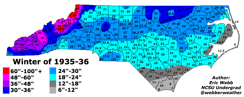
Please note that users can not only click on hyperlinks to individual storm dates but also each decade (except the 1890s), and all yearly titles are yet another hyperlink to a seasonal statewide snow and sleet accumulation map, estimated from the storms analyzed in each season. This site will be periodically updated as more winter storms are added to the archive
Any questions, comments, concerns, and/or feedback are strongly encouraged.
NC Winter Storm Maps By Decade
*Please note that this archive for NC after 1957 is currently incomplete*
Pre-1895 Winter Storm Maps
1890s NC Winter Storm Maps
1900s NC Winter Storm Maps
1910s NC Winter Storm Maps
1920s NC Winter Storm Maps
1930s NC Winter Storm Maps
1940s NC Winter Storm Maps
1950s NC Winter Storm Maps
1960s NC winter Storm Maps
1970s NC Winter Storm Maps
1980s NC Winter Storm Maps
1990s NC Winter Storm Maps
2000s NC Winter Storm Maps
2010s NC Winter Storm Maps
2020s NC Winter Storm Maps
NC Ice Storm Maps
NC Ice Storm Maps (1992-Present)
SC Winter Storm Maps
SC Winter Storm Maps
Misc. Winter Storm Maps
**Winter storm maps outside NC & SC**
Misc. Winter Storm Maps
Winter Storm Maps By Year
Seasonal statewide snow accumulation maps (NC)
*Seasonal statewide accumulation maps only available from 1895-1958 & 1967-68*
*Seasonal statewide snow accumulation maps (SC) (coming soon)*
NC & SC Winter Storm Climatology
NC Winter Storm Climatology Maps
*SC Winter Storm Climatology Maps (coming soon)*
Miscellaneous
Winter Storm Forecast Verification (2017-Present)
Nov-Apr Daily Teleconnections and NC Winter Storms List (1948-2021)
Fayetteville, NC Seasonal Snowfall (1871-2021)
Piedmont-Triad Int'l Airport (KGSO) Freezing Rain (ZR) Event Sounding Statistics (1976-2021)
Ensemble Oceanic Nino Index (ENS-ONI)
Ensemble Oceanic Nino Index (1850-Present)
Multivariate ENSO Index
Multivariate ENSO Index Version 2 (MEI.v2)
NCEP-R1 Multivariate ENSO Index (1948-Present)
Extended Multivariate ENSO Index (MEI.ext) (1871-2011)
Useful Links
Community Collaborative Rain, Hail, & Snow (CoCoRaHS) Network (1998-2021)
ECMWF Copernicus Climate Change Service (C3S)
Iowa State Environmental Mesonet NWS Product Archive (1983-Present)
IRI/LDEO Climate Library
KNMI Climate Explorer
Midwestern Regional Climate Center (MRCC) cli-MATE
National Operational Hydrologic Remote Sensing Center (NOHRSC) Snow Analyses (2003-Present)
NCEI Climate at a Glance
NCEI Image and Publication System (IPS) version 2.3
NCEI Regional Snowfall Index (RSI)
NC State Climate Office Winter Storm Database (1958-Present)
NewspaperArchive.com (for pre-1895 storms)
NOAA CSL Sudden Stratospheric Warming Compendium (SSWC)
NOAA ESRL 20th Century Reanalysis Composites (1836-2015)
NOAA ESRL NCEP Reanalysis Composites (1948-Present)
NOAA ESRL Web-based Reanalysis Intercomparison Tools (WRIT)
NWS GSP Local Data and Research
NWS CAE Archived Weather Events and Summaries
NWS ILM Wilmington, NC Snowfall Database Since 1870
NWS ILM Wilmington, NC List of Ice Storms Since 1947
NWS Local Storm Report App
NWS RAH Past Events Archive
thunderR - online rawinsonde & ERA5 browser (hourly, 1950-present)
SERCC NWS NOWData
South Carolina Winter Weather Database (1958-2020)
StratObserve (Zac Lawrence)
UKMET Meteocentre NOAA 20CRv2c, NCEP-R1 SLP & 500mb maps (1851-2018)
UNC-Charlotte Department of Geography & Earth Sciences
University of Berlin ECMWF Stratosphere Forecasts
Wolfpack Meteorology
xmACIS2 (Applied Climate System Information Tool)
